Arctic Summer Cloud-Ocean Study
Remote sensing of clouds
Information on clouds was also collected using surface-based remote sensing from two radars and one microwave radiometer. The main source of information comes from the MilliMeter Cloud Radar (MMCR) which is a vertically pointing Ka-band Doppler radar. The second radar is also a vertically pointing Doppler radar, but at the S-band. The MMCR, transmitting at 34 GHz, is very sensitive and ideal for probing low-level clouds, while the S-band radar is more adapted to measuring precipitation but can also be used for clouds. Both radars provide three main user products for every measuring volume (determined by the increasing width of the radar beam and the height discrimination): The radar reflectivity; essentially the power of the backscatter of the radar beam; 2) The mean Doppler velocity; the mean vertical speed of all the hydrometeors with respect to the radar, and; 3) The width of the Doppler spectra; all hydrometeors within each volume does not have the same vertical velocity. In addition to the radars a dual-wavelength radiometer was deployed, observing simultaneously the microwave radiation at two wavelengths, allowing the observation of the vertically integrated water vapor (PWV) and cloud liquid water (LWP). By a combination of the information from the MMCR, the microwave radiometer, the cloud base ceilometer and the soundings, one can also estimate various cloud microphysics parameter can be estimated.
Download
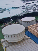 Photo of the cloud remote sensing instruments, showing the S-band radome in the back, the K-band MMCR on top of the radar container, containing all the electronics for both radars and the microwave radiometer at the bottom.